top of page

Local Trails: Hidden Gems Connect Us to Nature

Every day is a great day to get out and explore Kansas City’s natural areas. In honor of National Trails Day (June 2,) we asked some of our Alliance members to share with you some of their favorite natural excursions in Kansas City. Wherever you choose to venture make sure you stay hydrated, apply sunscreen, watch out for poison ivy and check for ticks when you get home. Happy trailblazing! Little Blue Trace Trail Brian Nowotny, Jackson County Parks and Recreation Near Corporal M. E. Webster Memorial Pkwy & Little Blue Pkwy, Independence, MO 64057. Visit here for more details and a full trail map. Difficulty Level: Easy to Moderate Description: 15.5 miles that is flat with occasional hills When to go: “The best time to go to avoid the crowds is early in the morning, after sun-up. However, if you walk the trail in the afternoon or early evening you can stop at the trailhead in Independence and get an ice cream treat at Cold-Stone Creamery, right on the trail! It’s quite the reward for a good bike or hike!” Favorite part about it: “The scenery is beautiful, mostly through wooded areas along the banks of the Little Blue River. Wildlife is abundant, including a few bald eagles if you know where to look. It is a long trail, 15.5 miles, so you can experience quite a diverse landscape if you travel the entire distance.” Blue River Parkway Trail Jill Erickson, Heartland Conservation Alliance

Blue River Road and E Blue Ridge Blvd. Visit here for more details about access and directions. Difficulty Level: Easy Description: 15 miles When to go: Any time Favorite part about it: "This is one of the easiest access points to see some of the less developed parts of the Blue River. The trail is paved and is a favorite for my youngest and I to explore. There is plenty of shade and we always catch a glimpse of wildlife. Once we head out on the trail, the city slips away and seems miles away."

HCA Board and staff at site visit to Blue River Parkway Trail.

Eddy-Ballentine Trail 7758 Blue River Road (About 1/2 mile south of the golf course) · Kansas City, MO Visit here for more details about access and directions. Difficulty level: Easy Description: 1.6 mile moderately trafficked loop that features beautiful wild flowers. The trail is primarily used for hiking, walking, nature trips, and birding and is accessible year-round.

Rocky Point Glade Ayana Curran-Howes, Heartland Conservation Alliance Swope Park, 3999 Swope Pkwy & E Meyer Blvd, Kansas City, MO 64132 Visit here for more details about access and directions. Difficulty Level: Moderate Description: 2.3 miles long, but Swope Park has many adjacent trails, totalling more than 50 miles in trails. When to go: “All seasons!” Favorite part about it: “I have gone in both fall and spring now and there is always a new native blooming and/or wildlife to discover. The first time I went out with Green Guard Stewards a wild turkey ran by us. They are much faster and bigger than I had imagined. Truly an amazing experience!” Cooley Lake Conservation trail Dan Allenbaugh, Exploring Roots Approx. 10 miles east of Worlds of Fun on 210 highway Visit here for more details about access and directions. Access a map, here. Difficulty level: Moderate Description: 3-mile loop that is not well maintained and can be hard to follow, but offers beautiful views and solitude When to go: “What I like about it are the views which make late Fall, winter, and early spring the best times to visit.” Favorite part about it: There is an observation deck and lake accessible within the 3-mile loop. West Ridge Trail Kendra Varn-Wallis, Missouri Department of Natural Resources Weston Bend State Park Visit here for more details about access and directions. Difficulty level: Easy to Moderate Description: 2.5 mile loop that is scenic with a river overlook, wildflowers and birding When to go: “I like to hike it in October to see the fall colors.” Favorite part about it: “Offers great views of the Missouri River.” Hidden Valley Natural Area Loop Savannah Horan, Research Medical Center North Kansas City Visit here for more details about access and directions. Find a map here. Difficulty level: Easy Description: 2.6 mile lightly trafficked loop that has a natural planting carried out by Kansas City Parks and Recreation, a lookout on a high wooded ravine and a cliff-side view of the Missouri River. When to go: “Not too many wildflowers this spring and as long as people are okay with lots of bugs and spider webs then I’d say this is a good time to go.” Favorite part about it: “My favorite part was how green and full the area was! It felt like you stepped into a rainforest. Definitely didn’t feel like you were right in the middle of KC! There were parts were vines and trees created a tunnel over the trail. it would also be killer for mountain biking! And the trail is very easy to follow.”

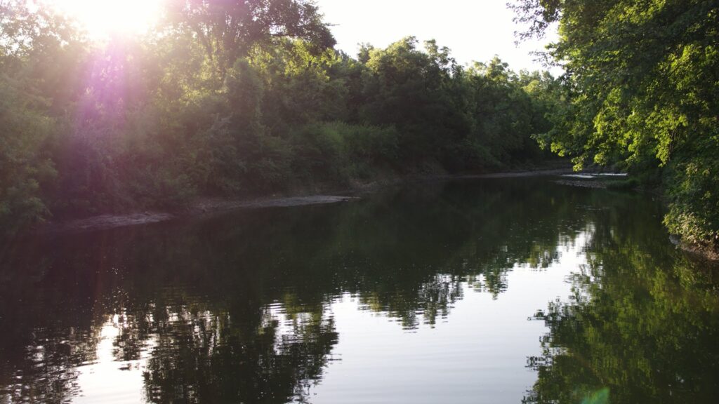
Blue River within Blue River Parkway Trail.

Find more resources for biking and hiking groups, maps and books below:

  • To find biking and trail work days along the Blue River, visit the Blue River Parkway Trail Facebook page, here.

  • Mid-America Regional Council has created an online and in-print trail map for bikers and hikers throughout Kansas City. Access it online or request a printed copy here.

  • Find the right trail for you here by searching for type, age of user and location at Kansas City Parks and Recreation or download a copy of trail maps here.

  • Learn about Bike Walk KC’s bike share program and biking events coming up here.

  • To read more about hiking in Kansas City, check out Hiking Kansas City by William B. Eddy and Richard O. Ballentine here.

148 views0 comments

Recent Posts

See All
bottom of page